25 km around Los Angeles

Viewpoints, waterfalls and hills near Los Angeles

Los Angeles within 25 km of downtown is a viewpoint list first: 42 of them, the City Hall Observation Deck 0.2 km from the center, Point Grandview at 3.4 km, Vista Viewpoint at 8.8 km. The San Gabriel foothills at the edge of the radius bring 13 waterfalls, Eaton Canyon Waterfall, Millard Falls and Ribbon Rocks Falls all around 20.7 km, and the Echo Mountain House ruin at 21 km. Mount Lee at 11.7 km and Mount Lukens at 24.1 km are the notable peaks.

Castles are thin, three in all, the Stimson House at 3.9 km among them, and the Bronson Caves at 10 km are the better bet. The Go For Broke Monument and Chicken Boy show the range of the 29 monuments. In a driving city, RLQuest wants the recorded route to say you walked.

42 Viewpoints30 Monuments13 Waterfalls11 Ruins7 Beaches and swimming spots4 Archaeological sites3 City gates3 Castles and palaces

Where the places are

Each hexagon covers a little over 5 square kilometers. The brighter it glows, the more places are inside it. The numbers mark the highlights listed below; the dot in the middle is the center of Los Angeles.

Few places to many

12

Worth the trip around Los Angeles

The places with the most to tell about. The numbers match the map.

Places by type

A selection for each type, best known first. The number next to each heading counts everything RLQuest knows within the radius.

Castles and palaces 3

  • Stimson House3.9 km

and 2 more

Viewpoints 42

  • City Hall Observation Deck0.2 km
  • Point Grandview3.4 km
  • Greenberg Memorial Bench8.3 km
  • Vista Viewpoint8.8 km
  • 5 Points9.0 km
  • Beachwood Dr. - Mid-block9.5 km
  • The Tiffany & Co. Foundation Overlook10 km
  • Dolby Family Terrace11 km
  • Tyrolean Tank Hollywood Sign Viewpoint11 km
  • Hollywood Sign Vista at Last House11 km
  • The Last House on Mulholland11 km
  • Cathy's Corner11 km

and 30 more

Waterfalls 13

  • Mayberg Waterfall20 km
  • Eaton Canyon Waterfall21 km
  • Ribbon Rocks Falls21 km
  • Millard Falls21 km
  • Moss Grotto Falls21 km
  • Grand Chasm Falls21 km
  • Thalehaha Falls21 km
  • Suspended Boulder Falls21 km
  • Roaring Rift Falls21 km
  • Leontine Falls21 km
  • Brown Mountain Dam Waterfall21 km
  • Bailey Canyon Falls22 km

and 1 more

Ruins 11

  • Echo Mountain House21 km

and 10 more

City gates 3

  • Prospect Studios6.6 km
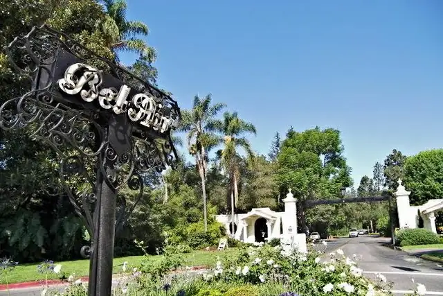
  • Bel Air West Gate20 km

Caves 2

  • The Grotto17 km

Archaeological sites 4

  • Kuruvungna Springs20 km

and 3 more

Monuments 30

  • Hollywood Sign12 km
  • Go For Broke Monument0.4 km
  • Chicken Boy7.7 km
  • Chinatown Gateway0.8 km
  • Los Angeles Sister Cities Monument0.1 km
  • George Washington statue0.5 km
  • Fort Moore Pioneer Memorial0.7 km
  • Los Angeles Memorial Coliseum Olympic Cauldron5.8 km
  • William Mulholland Memorial7.6 km
  • Astronomers' Monument9.1 km
  • Whitley Heights (Monument)10 km
  • Armenian Genocide Martyrs Monument11 km

and 18 more

Beaches and swimming spots 7

  • Mother's Beach21 km
  • Dockweiler State Beach22 km
  • Venice Beach22 km
  • El Segundo Beach23 km
  • Bay Street Beach24 km
  • Santa Monica State Beach24 km
  • Manhattan Beach24 km

Summits 34

  • Mount Lee12 km
  • Mount Lukens24 km
  • Olive Hill7.0 km
  • Adams Hill8.5 km
  • Beacon Hill9.0 km
  • Glendale Peak9.0 km
  • Fiji Hill9.2 km
  • Mount Hollywood10 km
  • Bee Rock10 km
  • Poppy Peak10 km
  • Taco Peak10 km
  • Mount Bell11 km

and 22 more

How Los Angeles turns into a game

RLQuest knows these places too. Which means:

1

Places become quests

Some of your daily quests lead to a real place near you. The app uses your location to check you were really there.

2

Being first pays off

If you're the first person in RLQuest to complete a quest at a place, it's your first find. The Place Book shows you which kinds of place you're still missing.

3

The map fills in

Every walk uncovers tiles, each about 350 m across. Over time you can see which corners you know well, and where you've never set foot.

App Store Google Play

In the region

Nearby cities

Place data © OpenStreetMap contributors, available under the Open Database License. As of 2026-10-02. The list shows the places RLQuest knows and isn't complete. Photos come from Wikimedia Commons; author and license are credited on each photo.